Seven Sisters
The Seven Sisters
Seven named cliffs, one unbroken ridgeline. England's last wild chalk coast
Seven named cliffs, one unbroken ridgeline. England's last wild chalk coast
The Seven Sisters (sometimes written 7 Sisters) are a series of seven white chalk sea cliffs on the East Sussex coast between Seaford and Eastbourne, within the South Downs National Park. The seven named cliffs, running west to east, are: Haven Brow (the highest, ~77m), Short Brow (the lowest, ~57m), Rough Brow, Brass Point, Flagstaff Point, Bailey's Hill, and Went Hill Brow. They are made of Cretaceous chalk laid down around 85 million years ago, form part of the Seven Sisters National Nature Reserve — one of the last stretches of undeveloped chalk coastline in England — and are free to visit year-round.
Four routes from easy to challenging — pick the right one for your day
🚂Trains, buses, parking and journey times from London and Brighton
📅Best time to go, crowd windows, and a full day itinerary
📖Everything in one place — safety, gear, tides, what to expect
Most people don't realise the Seven Sisters actually have names. They see the photos—those white cliffs rippling east from Cuckmere Haven—and assume it's just "the Seven Sisters," one entity. But each peak has its own name, its own character, and if you're walking them, you'll know the difference by the time your quads start complaining.
This page shows you exactly where each sister sits, what makes them distinct, and why these cliffs matter more than their more famous cousins in Dover. There's an interactive map below that marks each peak precisely, because the Ordnance Survey doesn't always get these right on standard maps.
Click any marker to see which cliff you're looking at. The seven peaks run west to east from Cuckmere Haven to Birling Gap—about 4km as the crow flies, closer to 6km if you're walking the ridge.
Seaford Head looking east—only place you can see all seven at once
~6km walking the full ridge from Cuckmere to Birling Gap
New · Interactive 3D Map
Fly to each sister, Cuckmere Haven, Birling Gap and Beachy Head in our immersive bird's-eye 3D map — tilt, rotate, and explore the whole coastline.
Walking from Cuckmere Haven, you hit them in this order. Each one's different—some are steep and brutal, others roll more gently. By the time you reach Went Hill Brow, you'll have climbed about 250 metres total elevation, though it feels like more because you're doing it seven times.
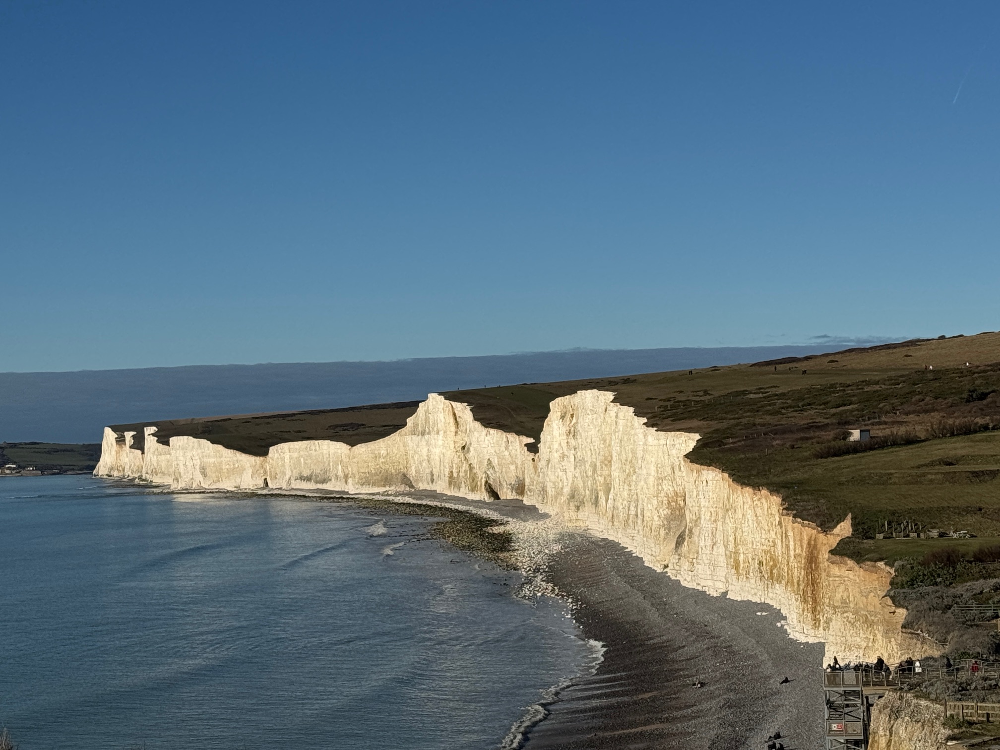
The first and highest of the seven at ~77 metres. "Haven" refers to Cuckmere Haven below—that's where the river meets the sea. This is the sister that appears in most photos because it's the most dramatic from Seaford Head. The climb up from Cuckmere beach is steep enough that you'll need to stop halfway and pretend you're just admiring the view.
Walking tip: If you're coming from the beach, take it slow. The path zigzags up and it's loose chalk in places.
Named because it's the shortest of the peaks—at around 57 metres, it's the lowest of the seven. The saddle between Haven Brow and Short Brow is the deepest dip on the whole ridge. You drop about 30 metres into the valley before climbing back up, which is when most people start questioning their fitness levels.
Worth noting: This is where the path gets properly narrow. Single file, cliff edge on your left, steep drop on your right.
Rough by name, rough by nature. The terrain here is more broken up—scrubby grass, rabbit holes, uneven ground. The cliff face shows more variation too, with bands of flint visible in the chalk. At ~68 metres, it's a substantial climb from Short Brow. This is where you start to realise the walk's going to take longer than you thought.
Geology note: The flint layers in the chalk here are more pronounced. On a sunny day they catch the light and stripe the cliff face dark grey.
Nobody's entirely sure where "Brass" comes from. Some say it's from the colour of the grass in certain light, others reckon it's a corruption of an old Sussex dialect word. Either way, this is a prominent headland that juts out further than the others. At ~64 metres, it sits at the midpoint of the ridge. From here you get a good view back west to Haven Brow and east toward Flagstaff Point.
This is roughly halfway. If you're flagging, this is where you need to decide whether to push on or turn back.
Named for the signal station that used to sit here—flags were flown to communicate with ships and other coastal stations. Nothing remains of it now, but the name stuck. At ~62 metres, it's slightly lower than Brass Point, which makes the approach feel a bit easier. The views from here are expansive: you can see right across to Beachy Head on a clear day.
Historical note: During the Napoleonic Wars, this was part of a signal chain running along the south coast. Messages could travel from Portsmouth to Dover in under an hour.
Probably named after a local landowner, though records are patchy. This is the gentlest of the sisters—more of a rolling slope than a sharp peak. At around 61 metres it sits low on the ridge, so the dip before it isn't as severe. By this point in the walk, you're either getting your second wind or seriously regretting your footwear choices.
This is where the chalk downland flora is most diverse. Look for wild thyme, horseshoe vetch, and if you're lucky in summer, pyramidal orchids.
The easternmost sister, sitting just before Birling Gap. At ~75 metres, it's a decent final climb. "Went" is Old English—possibly "winding" or "turning," which makes sense given how the coastline curves here. From the top, you can see the buildings at Birling Gap below and Beachy Head lighthouse in the distance. This is where the Seven Sisters officially end.
Final stretch: From here it's a short descent to Birling Gap where there's a cafe, pub, and toilets. You've earned all three.
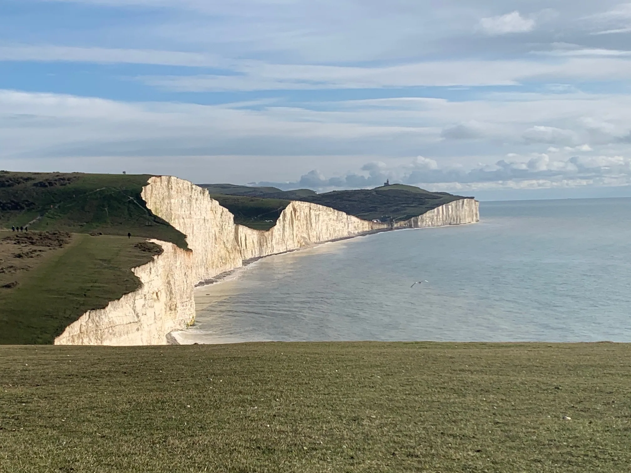
There's only one place where you can see all seven cliffs in a single view: Seaford Head, looking east toward Birling Gap. This is the classic viewpoint that appears in every photograph, film, and postcard of the Seven Sisters.
From the ridge itself, you can't see this perspective—you're too close, the scale's all wrong. But from Seaford Head, about 2km west of Haven Brow, the entire ridgeline unfolds before you. On a clear day with good light, it's genuinely spectacular.
The walk to Seaford Head takes about 20 minutes from Cuckmere Haven car park. Follow the coast path west, climb the initial slope (it's steep), and you'll hit the viewpoint at the top. There's no formal lookout point or sign—you'll know it when you see it.
The White Cliffs of Dover have a port, a castle, roads carved into them, buildings everywhere. The Seven Sisters have none of that. Not a single structure interrupts the ridgeline. This is what England's chalk coastline looked like before humans decided to build on it. There are maybe three or four stretches of undeveloped chalk coast left in southern England—this is the longest and most dramatic.
The cliffs are part of the South Downs National Park and the Sussex Heritage Coast, which means development is essentially impossible. The National Trust owns large sections. English Nature has designated it a Site of Special Scientific Interest (SSSI) for both geology and wildlife. Multiple layers of protection ensure these cliffs will stay wild.
The chalk here is Cretaceous—laid down about 85 million years ago when this area was underwater. You're looking at compressed marine sediments, the skeletons of billions of microscopic sea creatures. The flint bands running through the chalk are even older, formed from silica-rich organisms. The whole thing's a textbook example of how chalk landscapes form and erode.
Chalk grassland is one of England's rarest habitats—97% of it's been ploughed up or built on since 1945. The Seven Sisters are one of the few places where it still exists in anything like its original state. Skylarks, meadow pipits, kestrels, peregrine falcons. Rare butterflies like the Adonis blue. In the sea below, dolphins, porpoises, and occasionally seals. The whole system's interconnected.
The short version: Dover gets all the press because it's opposite France and has historical weight. But if you want to see what this coastline actually looks like without humans interfering, you come here. The Seven Sisters are rarer, wilder, and more ecologically significant than Dover's cliffs will ever be.
Chalk erodes constantly—that's how these cliffs formed in the first place. The sea undercuts the base, frost gets into cracks, and eventually large sections collapse. At Birling Gap, whole rows of coastguard cottages have fallen into the sea since the 1950s. The current cafe and visitor centre will go the same way eventually.
But here's the thing: the Seven Sisters aren't disappearing in any meaningful human timescale. Yes, they're eroding at 30–50cm per year on average. Over your lifetime, they'll retreat maybe 15-20 metres. That sounds like a lot until you remember the ridgeline is several hundred metres wide at its narrowest point. The shape might change slightly—peaks become less sharp, valleys fill in—but the basic form will outlast you, your children, and your grandchildren.
The real danger isn't erosion; it's complacency. Stand too close to the edge and you might trigger a collapse. Every year someone ignores the signs and gets caught out. The cliff edge is not stable—those fences are there for a reason.
Want the full picture of how these chalk cliffs formed, eroded and got their names? Read our complete guide to the Seven Sisters cliffs, or see how they compare to Dover, Beachy Head and the Jurassic Coast.
The classic walk is Seaford to Eastbourne (or vice versa), which takes you over all seven cliffs plus Seaford Head and Beachy Head. That's about 22km total—a long day. Most people do Cuckmere Haven to Birling Gap instead, which covers just the Seven Sisters themselves. Still ~6km, still a proper workout.
We may earn a small commission on bookings made through this link, at no extra cost to you. More info.
White chalk — compressed Cretaceous marine sediment formed from the skeletons of microscopic sea creatures, with bands of darker flint running through it. The chalk is soft and erodes constantly, which keeps the cliff faces a bright, clean white.
The chalk was laid down around 85 million years ago in the Cretaceous period, when this part of England lay beneath a warm shallow sea. The cliffs themselves were exposed far more recently, as the coastline eroded back after the last ice age.
They range from about 57 m to 77 m high. Haven Brow, the westernmost sister, is the highest at roughly 77 m; Short Brow is the lowest at around 57 m. They are lower than neighbouring Beachy Head (162 m), the highest chalk sea cliff in Britain.
There are seven distinct chalk hilltops along the ridge, each rising and dipping in sequence — historically likened to a row of sisters. Each has its own name: Haven Brow, Short Brow, Rough Brow, Brass Point, Flagstaff Point, Bailey's Hill and Went Hill Brow.
No. The Seven Sisters are a separate, undeveloped chalk formation between Cuckmere Haven and Birling Gap. Beachy Head sits just to the east, past Birling Gap; the White Cliffs of Dover are roughly 110 km further east in Kent. All three are chalk, but the Seven Sisters are the wildest and the only stretch with no buildings on the cliffline.
These cliffs have been here for millennia, shaped by ice ages, sea level changes, and the relentless work of waves. They'll be here long after we're gone. But right now, today, you can walk their ridge, see them from Seaford Head, or just sit at Cuckmere Haven and watch the light change across their faces.
Not many places in England feel this wild, this untouched. The Seven Sisters do. That's rare. That's worth protecting. And that's why people keep coming back.
In-depth guides to the Seven Sisters cliffs and the Sussex Heritage Coast.
£4.99 · 24-page PDF · Instant download
The complete 24-page companion built from first-hand walks — every cliff, all four graded routes, tide windows and a parking strategy. Designed to work offline, right on the cliff top.
Just want the basics? Download the free 2-page walk guide
Stay up to date with seasonal guides, crowd forecasts, and local tips — direct to your inbox.
No spam. Only coastal inspiration and timing tips — unsubscribe any time.